Hurricanes in history
1. GALVESTON HURRICANE
Location: Galveston, Texas
Stats
-
 Date: September 1900
-
 Intensity at landfall: Category 4
-
 Dead: At least 10,000
-
 Damage: 9,177 million dollars (2020 values)
Before
Though weather officials on the tip of Galveston Island were notified by telegraph of the coming storm, only half of the island's population evacuated.
- On September 8, the hurricane hit the island. Winds gusting to 225 kilometers (140 miles) an hour stripped roofs off homes and scrubbed areas clean of vegetation.
- The hurricane's most dangerous blow was its 4.6-meter (15-foot) high storm surge. Water submerged the city and roared down its streets.
- More than 3,600 homes were swept away. Survivors clung to floating roofs or treetops; others were washed away.
Aftermath
- Historians estimate that at least 10,000 people died in the storm, at least 6,000 of them on Galveston Island.
- Bodies not swept out to sea were piled in the city's business district where the hurricane had deposited them. More bodies clogged Galveston Bay.
- At St. Mary's Orphanage, panicked nuns tied children to their waists with clothesline to keep them close. After the storm the bodies of all ten nuns and 90 of the orphanage's 93 children were found nearby.
- The hot Texas weather made the massive numbers of decomposing bodies a serious health issue and funeral pyres were ordered. The smoke darkened the island for weeks.
- After the devastation of 1900, Galveston built a protective seawall which still stands today and raised the island's elevation.
-
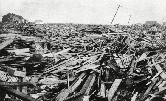
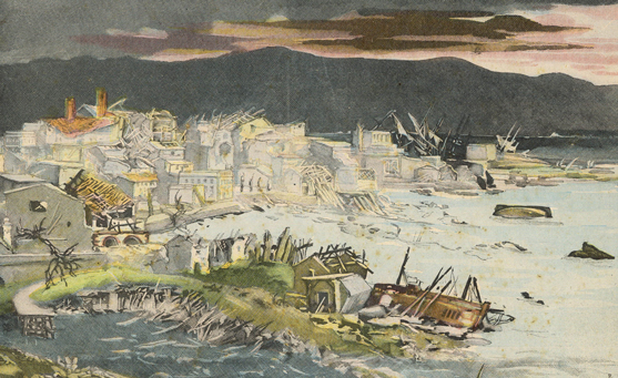
GREAT STORM A large part of the city of Galveston, Texas was reduced to rubble, as shown in this September 1900 photo, after being hit by a surprise hurricane. Photograph courtesy AP/Shutterstock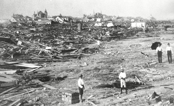
A large part of the city of Galveston, Texas was reduced to rubble, as shown in this September, 1900 photo, after being hit by a surprise hurricane. More than 6,000 people were killed and 10,000 left homeless from the Great Storm. Photograph courtesy AP/Shutterstock -
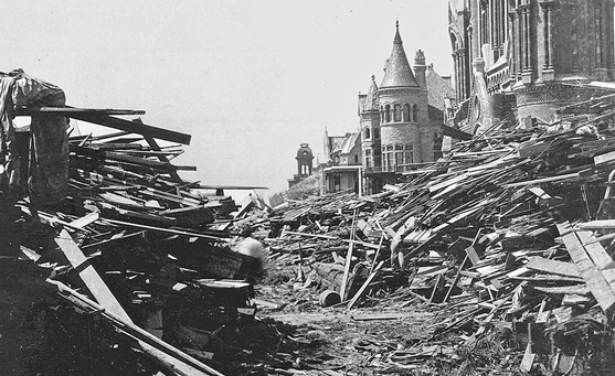
The Gresham house, center, now known as the Bishop's Palace, sits relatively unscathed behind a wall of debris following the hurricane that devastated Galveston, Texas. More than 6,000 people were killed and 10,000 left homeless as entire neighborhoods were swept clean. Heavily damaged Sacred Heart Catholic Church is at right. Photograph courtesy Anonymous/AP/Shutterstock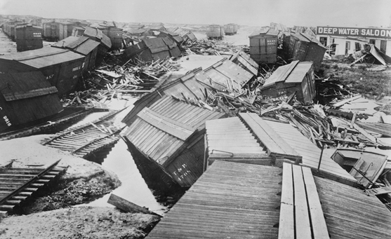
Hurricane destruction, Galveston, Texas, USA, Bain News Service, September 1900. Photograph courtesy Glasshouse Images/Shutterstock -
Galveston, Texas is devastated by a severe storm, 1900. Photograph courtesy Historia/Shutterstock
2. HURRICANE CAMILLE
Location: U.S. South
Stats
-
Date: August 1969
-
Intensity at landfall: Category 5
-
Dead: 256
-
Damage: 9.8 billion dollars (2020 values)
Before
August 14 - storm formed west of Cayman Islands
August 15 - by western Cuba intensified into a Category 3 hurricane.
August 16 - in Gulf of Mexico became a Category 5 hurricane
August 17 - made landfall along the Mississippi coast
Damage
- When Camille slammed into the coast on August 17 with Category 5 fury, the hurricane killed more than 140 people.
- In Pass Christian the hurricane's immense seven-meter (24-foot) storm surge roared into the apartment building demolishing the structure.
- Within 30 minutes of rushing in, the storm tide retreated, dragging tons of hurricane debris with it into the ocean.
- More than 5,000 homes were demolished and 40,000 more were damaged along the lower Louisiana peninsula and in Mississippi.
Aftermath
- The hurricane destroyed all wind-measuring instruments. Scientists estimated winds neared 322 kilometers (200 miles) an hour.
- After wrecking the coast, Camille tracked inland across Louisiana and weakened into a tropical depression. As the storm approached the Appalachian Mountains in southern Virginia, it intensified and produced a new round of torrential rains.
- In Nelson County, Virginia, 71 centimeters (28 inches) of rain fell in eight hours causing flash floods and landslides. Entire communities were swept away and 153 people died.
- In all, Hurricane Camille caused damages in excess of $9.8 billion (2020 values). It was the second strongest hurricane of the 20th century, behind an unnamed hurricane that struck the Florida Keys in 1935.
-
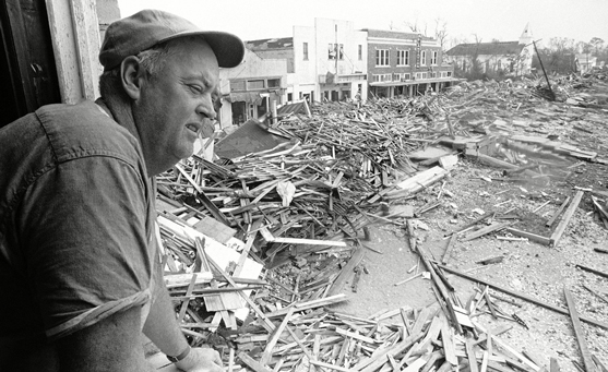
Pass Christian Civil Defense Director Parnell McKay looks over the town's main business district after hurricane Camille passed through. Photograph courtesy Jack Thornell/AP/Shutterstock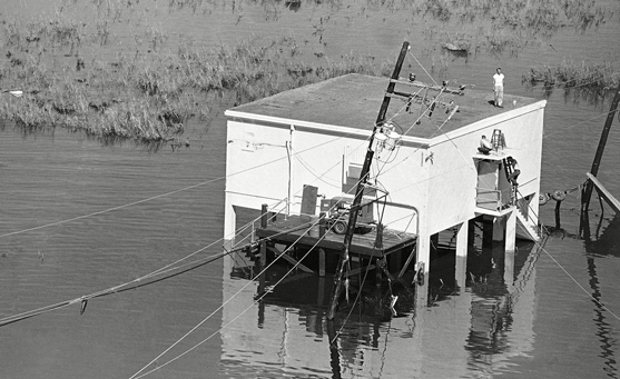
Refugees of Hurricane Camille have no place to go as they are stranded by high water atop a structure at Venice, Louisiana, which was hard hit by the storm. Southeast Louisiana and the Mississippi Gulf Coast have been declared disaster areas. Photograph courtesy Jack Thornell/AP/Shutterstock -
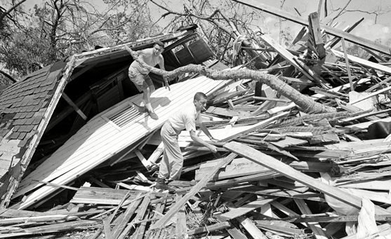
John Burk, foreground and Carl Wilson (top, back) survey the damage to their Long Beach, Mississippi house. Burk was blown into a tree by Hurricane Camille Sunday night and rode out the storm in his perch. Wilson ended up under the house when it collapsed. Neither was injured but two other people in the house died. Photograph courtesy Jack Thornell/AP/Shutterstock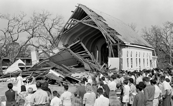
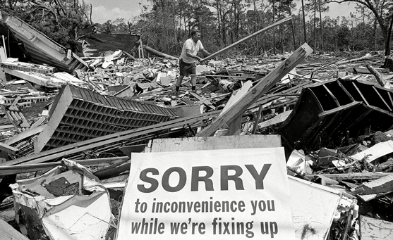
Father William Pittman, left, conducts an outdoor Mass outside the ruins of St. Thomas Catholic Church at Long Beach, Mississippi, just one week after Hurricane Camille took a heavy toll on the Mississippi Gulf Coast. The church (background) was hard hit by the storm but the pastor told the congregation they would build again. Photograph courtesy Jack Thornell/AP/Shutterstock -
Service station owner H.A. Torgerson moves debris in what had been the town post office, next door to his station in Waveland, Mississippi; Hurricane Camille had devastated the area about three weeks earlier. Photograph courtesy Jack Thornell/AP/Shutterstock
3. HURRICANE HUGO
Location: South Carolina, North Carolina
Stats
-
Date: September 1989
-
Intensity at landfall: Category 4
-
Dead: 82
-
Damage: 15 billion dollars (2020 values)
After smashing Guadeloupe, Montserrat, and the U.S. Virgin Islands on September 17, Hurricane Hugo brushed Puerto Rico and headed for the U.S. coast, intensifying into a Category 4 storm.
Damage
- On September 21, Hugo slammed into Charleston, South Carolina, with winds topping 222 kilometers (138 miles) an hour. The storm surge was 32 meters (20 feet) high, the highest ever recorded on the U.S. East Coast.
- South Carolina's barrier islands were devastated. Homes were swept clean off their foundations. The Atlantic House, a restaurant built over the water, disappeared in the storm, leaving only its pilings behind.
- More than half of Charleston's 4,000 historic buildings were damaged. The Ben Sawyer Bridge over the Atlantic Intracoastal Waterway was partially submerged, and huge oak trees were toppled like bowling pins.
- Tens of thousands of loblolly pines in Francis Marion National Forest were sheared off, a loss of timber estimated at over 1 billion dollars.
- Hugo maintained 161 kilometer (100 mile) an hour gusts, even when it was almost 322 kilometers (200 miles) inland. Power was lost in most of the city of Charlotte, North Carolina, and 80,000 trees there were destroyed.
Aftermath
With a price tag of seven billion dollars, Hugo held the title of costliest storm until Hurricane Andrew in 1992.
-
A man stands in a partially destroyed house September 27, 1989 in South Carolina. Hugo is ranked as the eleventh most intense hurricane to strike the US this century and is rated the second costliest with over seven billion dollars in damages. Photograph courtesy Alan Weiner / Getty Images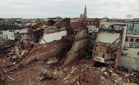
September 23, 1989–Charleston, South Carolina–Storekeepers (top right) survey extensive damage from roof, caused by Hurricane Hugo as it slammed into Charleston Carriage Company, destroying the building and scattering debris. The building, in downtown Charleston on the wharf, used to also stable horses for the carriages. Photograph courtesy Bettmann / Getty Images -
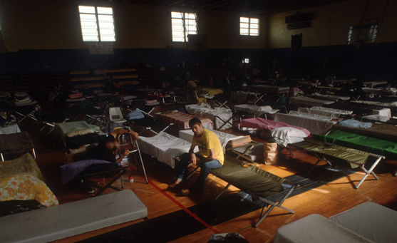
People lie on cots in a shelter September 27, 1989 in South Carolina. Hugo is ranked as the eleventh most intense hurricane to strike the US this century and is rated the second costliest with over seven billion dollars in damages. Photograph courtesy Alan Weiner / Getty Images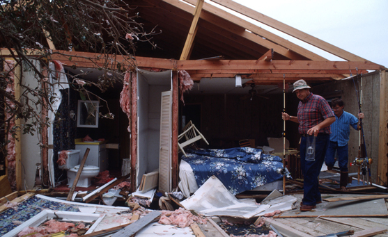
Men carry fishing poles through the remains of a home September 27, 1989 in South Carolina. Hugo is ranked as the eleventh most intense hurricane to strike the US this century and is rated the second costliest with over seven billion dollars in damages. Photograph courtesy Alan Weiner / Getty Images -
Photograph courtesy NOAA / Satellite and Information Service
4. HURRICANE ANDREW
Location: South Florida
Stats
-
Date: August 1992
-
Intensity at landfall: Category 5
-
Dead: Thanks to accurate forecasts and an intense public-awareness push, the storm claimed only 23 lives.
-
Damage: 46 billion dollars (2020 values)
Before
Meteorologists at the U.S. National Hurricane Center kept a close eye on the storm from its beginnings on August 14. It became a tropical storm on August 17 and was dubbed Andrew.
This small and powerful hurricane was the most expensive natural disaster ever to hit the United States. Thanks to accurate forecasts and an intense public-awareness push, the storm claimed only 43 lives.
Damage
-
As Andrew bore down on South Florida, officials ordered massive evacuations.
- 55,000 people left the Florida Keys.
- 517,000 people in Dade County were told to leave.
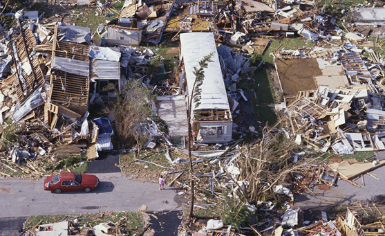
- On August 24, the hurricane slammed into southern Dade County, with winds topping 266 kilometers (165 miles) an hour. Unusually, wind—not storm surge or rain—was the most destructive force. Only about 18 centimeters (seven inches) of rain fell on the state.
- Violent winds destroyed more than 25,000 houses and damaged more than 100,000 others.
- More than 150,000 people were left homeless
- 86,000 people lost their jobs.
- Thousands of cars were totaled.
- Fifteen thousand boats were destroyed, piled in harbors like dominoes.
- More than 150 airplanes were mangled beyond repair.
- In the Everglades, 28,000 hectares (70,000 acres) of native mangrove trees were decimated.
Aftermath
After the storm, shell-shocked Floridians were without power, water, food, or shelter from the broiling sun. The National Guard was called out to control rampant looting and eventually every branch of the U.S. armed forces was deployed to help clean up and restore order to south Florida.
-
On the week of August 24, 1992, Atlantic-born Hurricane Andrew ripped through south Florida, barreled its way northwest across the Gulf of New Mexico, and slammed into Louisiana roughly one hundred miles southwest of New Orleans. Photograph courtesy NASA GSFC Visualization Analysis Laboratory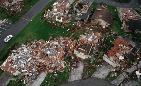
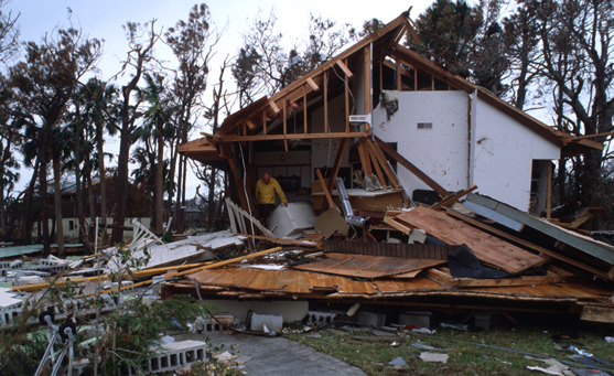
The remains of Montego Bay, a housing development in Dade County, Florida, wrecked by Hurricane Andrew in 1992. Photograph by Raymond Gehman / Getty Images -
Remnants of a trailer park following Hurricane Andrew. Photograph courtesy Steven D Starr / Getty Images
Only piles of rubble remain of a trailer park following Hurricane Andrew. Photograph courtesy Steven D Starr / Getty Images -
Wreckage from Hurricane Andrew in Homestead in September 1992. Photograph courtesy Sun Sentinel / Getty Images
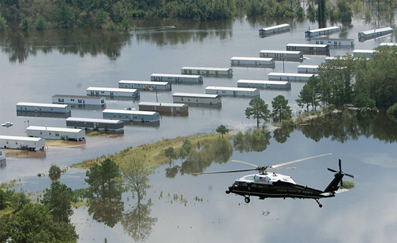
5. HURRICANE FLOYD
Location: North Carolina
Stats
-
Date: September 1999
-
Intensity at landfall: Category 2
-
Dead: 57
-
Damage: 9 billion dollars (2020 values)
Before
Hurricane Floyd was just a Category 2 storm when it made landfall near Cape Fear, North Carolina, on September 16, 1999.
Damage
- Its torrential rains caused widespread flooding and billions of dollars in damage.
- Floyd moved in on the Carolina coast after storming through the central Bahamas and leaving one person dead there.
- The diameter of the huge storm ranged from 800 to 966 kilometers (500 to 600 miles).
- Hurricane watches were first issued for areas stretching from Dade County, Florida, to north of Brunswick, Georgia. Three million people were evacuated in Florida, Georgia, and South Carolina.
- Then Floyd turned to the north, hitting North Carolina and dumping 38 centimeters (15 inches) of rain on the state in just 24 hours. The deluge followed just 10 days after Tropical Storm Dennis had dumped 15 centimeters (6 inches) of rain on the same area.
- Rivers and creeks crested at levels not seen for centuries. People were stranded on cars and rooftops. Water overflowed into fields and farms, leaving more than three million dead turkeys, chickens, and hogs. Corn, cotton, and peanut crops were damaged.
- Along the Tar River, the water crested at 7.3 meters (24 feet) above flood level, wiping out the town of Princeville.
Aftermath
Floods were responsible for 50 of the 56 deaths caused by Floyd in the United States.-
Marine One carrying US President Bill Clinton along with North Carolina Governor James Hunt September 20, 1999, survey the flood damage over Tarboro, North Carolina, which was damaged by high winds and rain from Hurricane Floyd. Clinton also visited emergency shelters. Photograph courtesy Stephen Jaffe / Getty Images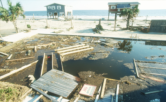
Photograph courtesy Robert Nickelsberg / Getty Images -
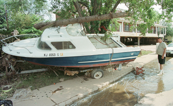
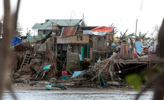
BOUND BROOK, UNITED STATES: Rich Yannetta (R), owner of Yannetta's Bait and Tackle in Bound Brook, New Jersey, looks September 20, 1999, at where his boat came to rest after being pushed more than one block by the flood waters of the Raritan River in this Central New Jersey town in the wake of Hurricane Floyd last week. Yannetta's business was one of dozens in the town that were destroyed by the high water. Photograph courtesy Tom Mihalek / Stringer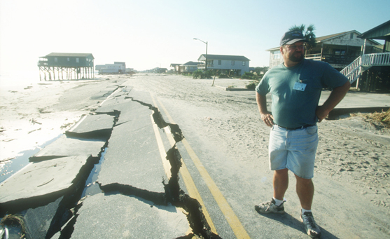
An unidentified man stands on a damaged road September 18, 1999 in Oak Island, North Carolina. The eye of Hurricane Floyd passed over the island leaving a trail of damaged homes and heavy flooding. Photograph courtesy Robert Nickelsberg / Getty Images -
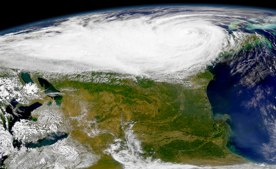
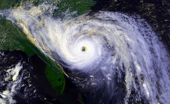
SeaWiFS captured this view of Hurricane Floyd against the image of the Earth. Photograph provided by the SeaWiFS Project, NASA/Goddard Space Flight Center, and ORBIMAGE
6. TYPHOON TORAJI
Location: Taiwan, China
Stats
-
Date: July 2001
-
Dead: Estimated at more than 200
-
Damage: More than 100 million U.S. dollars
Typhoon Toraji, named for a popular plant in Korea, swept through eastern and central Taiwan, China, on July 30, 2001.
Damage
- The storm lingered for ten hours, dumping rain on the island.
- The east-central county of Hualien and the central county of Nantou were the hardest hit.
- Tens of thousands of people were left without power.
- Landslides swept houses off their foundations.
- Boulders crashed down mountains, knocking trees over and slamming into homes.
Aftermath
- Agricultural damage was estimated at a hundred million U.S. dollars.
- After leaving Taiwan, the storm turned toward mainland China. More than 300,000 people were evacuated from the eastern coastal provinces, but Toraji weakened and did no real damage there.
-
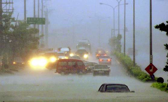
Cars lie submerged on a flooded highway in Taiwan's mountainous county of Nantou as Typhoon Toraji slammed into eastern and central Taiwan, July 30, 2001. The storm, packed with driving winds and torrential rain, killed at least 14 people and left 33 people missing. Photograph courtesy STR/TAIWAN/REUTERS/Newscom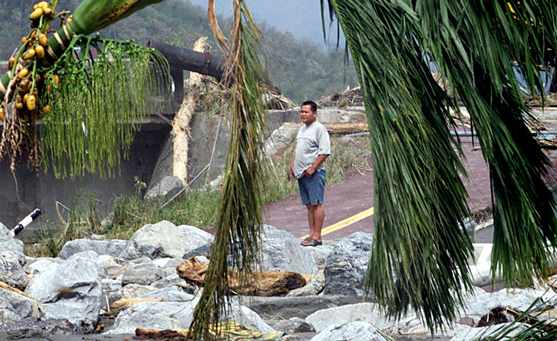
A man looks at his destroyed home and property in the east coast county of Hualien on July 31, 2001, after Typhoon Toraji swept across the island of Taiwan. Toraji hit on Monday, killing at least 61 people in floods, mud and rock slides and leaving about 152 missing, many believed to be buried alive. Photograph courtesy SIMON KWONG/REUTERS/Newscom -
Rescuers in Taiwan's central province of Nantou inspect a house gutted by a landslide caused by rains from Typhoon Toraji on August 1, 2001. Photograph courtesy STR/TAIWAN/REUTERS/Newscom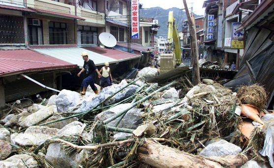
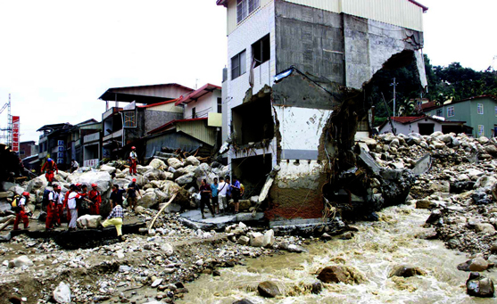
Workers climb over debris piled two stories high on a street in Nantou after a rockslide caused by rains from Typhoon Toraji on August 1, 2001. Some 134 people remain missing after they were swept away or buried by landslides and flood waters after Toraji swept across the island on Sunday and Monday. The death toll from the storm stood at 72 on Wednesday, but hopes of finding survivors are growing dim. Photograph courtesy STR/TAIWAN/REUTERS/Newscom -
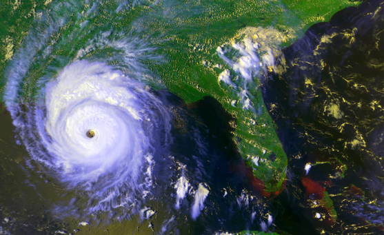
Packing torrential rains and wind gusts of up to 145 kilometers (90 miles) per hour, Typhoon Toraji swept across Taiwan today (July 30, 2001) leaving a swath of death and destruction in its wake. At least 35 people were killed, and another 103 are missing, by the widespread flooding and mudslides produced by the storm. Image courtesy the SeaWiFS Project, NASA/Goddard Space Flight Center, and ORBIMAGE
7. Cyclone Idai
Location: Mozambique, Zimbabwe and Malawi
Stats
-
Date: March 14, 2019
-
Dead: approximately 1,300 dead, many more missing
-
Damage: more than $2 billion
Cyclone Idai caused catastrophic damage and a humanitarian crisis in Mozambique, Zimbabwe and Malawi.
Tropical Cyclone Idai made landfall directly on top of Beira, Mozambique, as a Category 2 storm with sustained winds exceeding 169 kilometers (105 miles) an hour and a storm surge more than 6 meters (20 feet) high. This, alongside the torrential rain, resulted in flooding. The river Buzi burst its banks flooding an area 50 kilometers (30 miles) long. Beira, the fourth-largest city in Mozambique, was home to a population of 530,000.
The storm swept across Mozambique before turning inland into neighboring countries Malawi and Zimbabwe. It is estimated that more than 1.5 million people in the three nations were affected.
Aftermath
- Idai dissipated on March 21.
- It had dumped heavy rain on 23,000 square kilometers (900 square miles) that’s larger than New York City and Los Angeles combined.
- In Mozambique, the storm inundated more than 360,000 hectares (900,000 acres) of crops, damaged at least 17,000 houses and dozens of health units.
- Flooding and landslides drastically altered the landscape in eastern Zimbabwe.
-
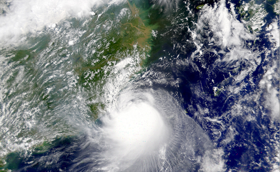
Tropical Cyclone Idai is poised to move inland over East African countries already soaked with rain. NASA Earth Observatory image by Lauren Dauphin, using VIIRS data from the Suomi National Polar-orbiting Partnership. Caption by Kathryn Hansen.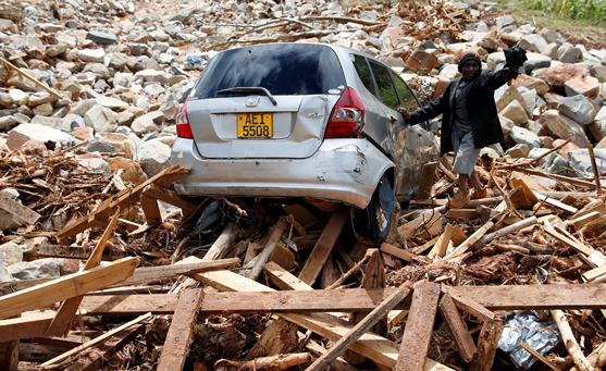
A man gestures next to his car after it was swept into debris left by Cyclone Idai in Chimanimani, Zimbabwe, March 23, 2019. Photograph by Philimon Bulawayo -
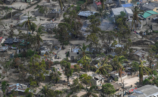
An aerial view of the aftermath of the massive Cyclone Idai destroying huge swaths of the region April 8, 2019 near Bebedo, Mozambique. The World Food Programme, with help from the U.S. Air Force is transporting emergency relief supplies to assist the devastated region. Photograph courtesy US Air Force Photo / Alamy Stock Photo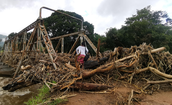
A villager crosses a damaged bridge close to a village swallowed by a landslide triggered by Cyclone Idai in Rusitu, Manicaland Province, Zimbabwe, March 23, 2019. Photograph courtesy Xinhua / Alamy Stock Photo -
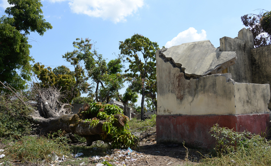
September 3, 2019, Beira, Mozambique: Destroyed latrines of a school in Dondo, outside the city of Beira. They were destroyed by Cyclone Idai. The aid organisation Care is helping with the reconstruction of the latrines. The damage caused by Cyclone Idai in Mozambique has a long-term effect. Many people have also lost their harvest–a food crisis threatens. Photograph courtesy dpa picture alliance / Alamy Stock Photo
8. Super Typhoon Haiyan (local name Yolanda)
Location: Southern Philippines
Stats
-
Date: November 8, 2013
-
Dead: approximately 6,300 dead and more than 1,000 missing in April 2014
-
Damage: $5.8 billion (2013 USD)
Before
- November 3rd - A low pressure storm formed near Micronesia
- November 5th - Storm intensified into a typhoon
- November 6th - Storm intensified further into a super typhoon.
- November 7th (5 hours before landfall) - Haiyan's intensity peaked with 1-minute sustained winds of 314 kilometers (195 miles) per hour - it is assigned Category 5 equivalent Super Typhoon.
- November 8th - The wind speed at landfall (east coast of Samar and Leyte) of 314 kilometers (195 miles) per hour were the strongest tropical cyclone winds to impact land, surpassing Hurricane Camille’s winds of 306 kilometers (190 miles) per hour (1969 U.S.).
- At its first landfall in the Visayas region it lost no intensity.
- Gradually weakening, the storm made five additional landfalls in the country before emerging over the South China Sea where it went onto impact southern China and Vietnam.
Damage
- Category 5 Haiyan struck the Visayas region with devastating winds and towering waves that swept away government-designated storm shelters.
- In Tacloban, winds blew a wall of water ashore 7.5 meters (24.6 feet) high. This was devastating as most of the city is less than 5 meters (16 feet) above sea level.
- People did not expect flood water from the storm surge. This was up to 5.2 meters (17 feet) in Tacloban, northeast of Leyte.
Aftermath
- Six million workers lost their sources of income.
- Major rice, corn and sugar-producing areas for the Philippines were destroyed, affecting farmers' incomes and the country's international trade.
- Fishing communities were severely affected, with the storm destroying 30,000 boats and associated equipment.
- There were outbreaks of disease due to the lack of sanitation, food, water, shelter, and medication.
- Less-affected areas reported that their populations more than doubled after the typhoon with the influx of refugees.
- The Tacloban city government was devastated, with only 70 people at work in the immediate days after the disaster compared to 2,500 normally. Many were killed, injured, lost family or were simply too traumatised to work.
- Tacloban's city airport was severely damaged, affecting business and tourism.
- More than 7,000 people were killed by Typhoon Haiyan.
- 1.9 million people were left homeless and more than 6,000,000 displaced.
- In the city of Tacloban, widespread looting took place in the days following the typhoon.
- Widespread floods damaged and in many cases destroyed homes and businesses in coastal areas.
- The Philippine government estimated that about 71,000 hectares of farmland was affected.
- Thousands of trees were uprooted leading to a massive release of carbon dioxide and loss of habitat with resulting effects on wildlife.
- Flooding knocked over Power Barge 103 causing an oil spill affecting mangrove ecosystems.
- Major roads were blocked by trees, and were impassable.
Did you know?
Historically high sea levels may have contributed to the storm’s destructive force. Sea level around the central Philippines has risen 200 millimeters (7.9 inches) since 1970.
Haiyan was unusual not just for its record strength, but for its location: it’s very uncommon for tropical cyclones to form so close to the equator.
-
Daanbantayan, Cebu, Philippines. November 10, 2013. Damaged houses along the shoreline of Daanbantayan, Cebu, Philippines in the wake of Typhoon Haiyan. Photograph courtesy imagegallery2 / Alamy Stock Photo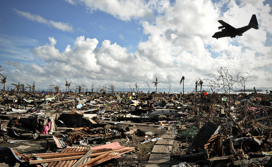
Tacloban, Philippines. November 15, 2013. A military aircraft passes by washed-out village. Typhoon Haiyan ripped through the Philippines over the weekend and has been described as one of the most powerful typhoons, leaving thousands dead and hundreds of thousands homeless. Photograph courtesy ZUMA Press, Inc. / Alamy Stock Photo -
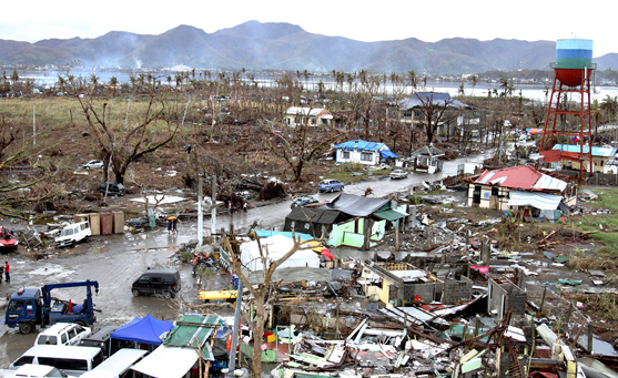
Aerial view of the destruction and damage by Typhoon Haiyan November 23, 2013 in Tacloban, Philippines. Photograph courtesy US Marines Photo / Alamy Stock Photo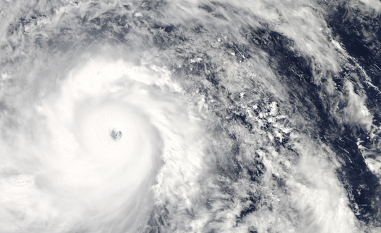
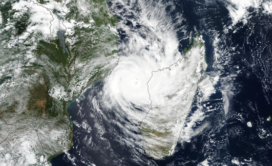
The Moderate Resolution Imaging Spectroradiometer (MODIS) on NASA’s Aqua satellite acquired this natural color image of Super Typhoon Haiyan as it moved west toward the coast of the Philippines. Image courtesy NASA / LANCE / EOSDIS MODIS Rapid Response Team at NASA GSFC. Caption by Mike Carlowicz. -
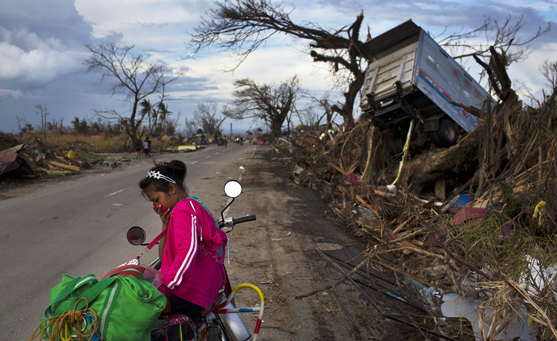
A woman rests on a roadside with her family's belongings near typhoon wreckage. Photograph courtesy AP / David Guttenfelder