What are hurricanes?
A hurricane is a rotating tropical storm with winds of at least 119 kilometers (74 miles) an hour.
Video courtesy of James Reynolds / Getty ImagesThey are called:
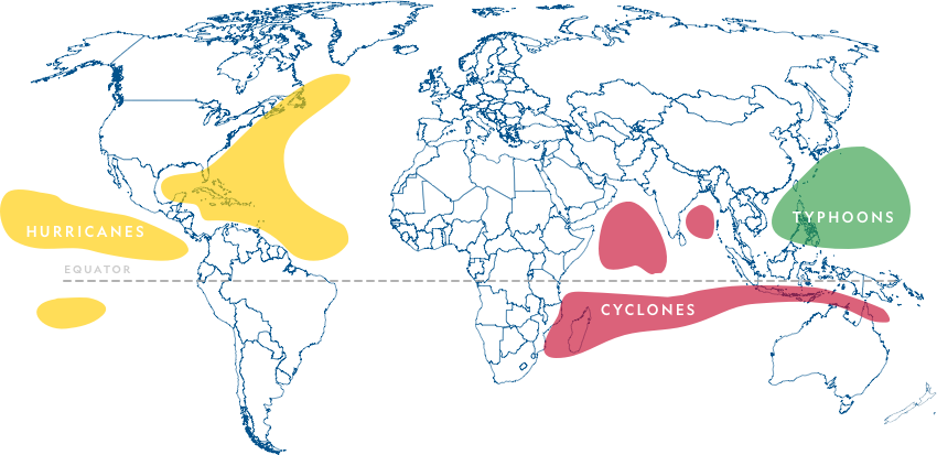
- hurricanes when they develop over the Atlantic or eastern Pacific Oceans.
- cyclones when they form over the Bay of Bengal and the North Indian Ocean.
- typhoons when they develop in the Western Pacific.
The scientific name for all three is tropical cyclone.
Whatever their names, they are all formed in the same way and are capable of destroying areas and causing massive death tolls.
Did you know?
Hurricanes spin with a counterclockwise spin in the Northern Hemisphere and a clockwise spin in the Southern Hemisphere.
How hurricanes form
Did you know?
The word ‘hurricane’ comes from huracan, the Carib Indian name for the storm god.
Anatomy of a Hurricane
Once a hurricane forms, it has three main parts.
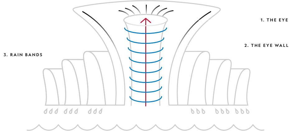
1. THE EYE — usually between 32 to 48 kilometers (20 to 30 miles) wide.
Air sinks inside the eye, clearing the skies and making it relatively calm. This calm often fools people into believing the storm has passed when in fact they are in the middle of it.
2. THE EYE WALL — surrounds the eye.
The hurricane's fastest, most violent winds and most intense rains are here. Air is rising fastest here and condensation rates are maximized in the towering cumulonimbus clouds.
3. RAIN BANDS — the outermost layer of the hurricane.
Rain bands are the first signs of the coming storm.
Where and when hurricanes form
Tropical cyclones are fueled by warm, moist air, which is why they only form over warm oceans that are near the equator. The map below shows you where hurricanes, cyclones, and typhoons form.
Select the to see which direction hurricanes, typhoons, and cyclones travel in and when their seasons are.
Type: Hurricane
Season: runs from June 1st through November 30th

Type: Hurricane
Season: runs from May 15th through November 30th

Type: Typhoon
Season: runs from June 1st through November 30th

Type: Cyclone
Season: runs between April and December

Type: Typhoon
Season: runs between April and January

Did you know?
The Western Pacific sees more tropical storms and typhoons each year than any other ocean basin.
Are hurricanes, cyclones and typhoons getting more intense?
Rises in sea level will most likely cause higher coastal inundation levels for tropical cyclones that occur.
Tropical cyclone rainfall rates are likely to increase.
The global proportion of Category 4 and 5 tropical cyclones is likely to increase, resulting in storms of unprecedented strength.
Did you know?
Hurricanes do have an important job. Tropical cyclones bring nutrient-rich colder water from depth up to the surface – resulting in algal blooms in their wake.
Damage hurricanes do
Meteorologists use the Saffir-Simpson hurricane wind scale to rank a hurricane's intensity. Wind speeds determine which category a hurricane falls into.
Saffir-Simpson hurricane Wind Scale
Select a category to find out about the level of damage done.
-
 Sustained winds
119-153 kilometers per hour
Storm surge
(74-95 miles per hour)
(64-82 knots)1.2-1.5 meters
(4-5 feet)Very dangerous winds will produce some damage:
- Well-constructed frame homes could have damage to roof, shingles, vinyl siding, and gutters.
- Large branches of trees will snap and shallowly rooted trees may be toppled.
- Extensive damage to power lines and poles likely will result in power outages that could last a few to several days.
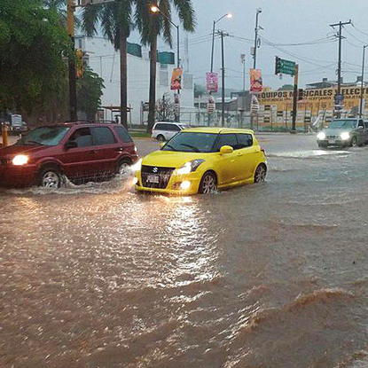
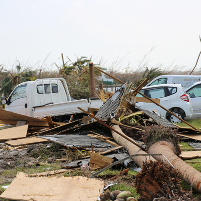
Image: Cars travel along a flooded street after heavy rain caused by Tropical Storm Lorena hit the area around Culiacán, Sinaloa, Mexico, 19 September 2019.
Photograph courtesy JUAN CARLOS CRUZ/EPA-EFE/Shutterstock
-
 Sustained winds
154-177 kilometers per hour
Storm surge
(96-110 miles per hour)
(83-95 knots)1.8-2.4 meters
(6-8 feet)Extremely dangerous winds will cause extensive damage:
- Well-constructed frame homes could sustain major roof and siding damage.
- Many shallowly rooted trees will be snapped or uprooted and block numerous roads.
- Near-total power loss is expected with outages that could last from several days to weeks.
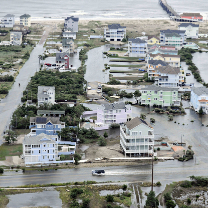
Image: Aerial view of flooding caused by hurricane Arthur on the Outer Banks. Hurricane Arthur was the earliest hurricane to ever hit the Outer Banks. (Nags Head, NC, USA. July 4, 2014)
Photograph by P David Weydert
-
 Sustained winds
178-208 kilometers per hour
Storm surge
(111-129 miles per hour)
(96-112 knots)2.7-3.7 meters
(9-12 feet)Devastating damage will occur:
- Well-built framed homes may incur major damage or removal of roof decking and gable ends.
- Many trees will be snapped or uprooted, blocking numerous roads.
- Electricity and water will be unavailable for several days to weeks after the storm passes.
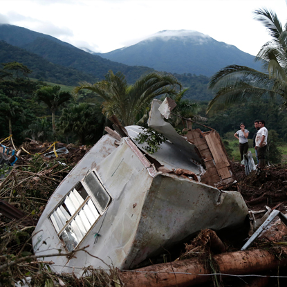
Image: People stand near the site damaged by Hurricane Otto in Bijagua, in the Alajuela province, Costa Rica, November 25, 2016. The government of Costa Rica confirmed Friday that Hurricane Otto had killed at least nine people in the country, after the storm battered northern regions.
Photograph courtesy Xinhua / Alamy Stock Photo
-
 Sustained winds
209-251 kilometers per hour
Storm surge
(130-156 miles per hour)
(113-136 knots)4-5.5 meters
(13-18 feet)Catastrophic damage will occur:
- Well-built framed homes can sustain severe damage with loss of most of the roof structure and/or some exterior walls.
- Most trees will be snapped or uprooted and power poles downed.
- Fallen trees and power poles will isolate residential areas.
- Power outages will last weeks to possibly months.
- Most of the area will be uninhabitable for weeks or months.
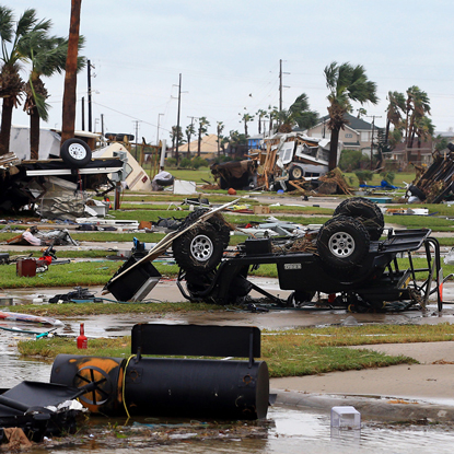
Image: Port Aransas, Texas, USA. A mobile home park is destroyed after Hurricane Harvey landed in the Coast Bend area on Saturday, August 26, 2017, in Port Aransas, Texas.
Photograph courtesy Tribune Content Agency LLC / Alamy Stock Photo
-
 Sustained winds
252 kilometers per hour or higher
Storm surge
(157 miles per hour or higher)
(137 knots or higher)5.8 meters
(19+ feet)
Catastrophic damage will occur:
- A high percentage of framed homes will be destroyed, with total roof failure and wall collapse.
- Fallen trees and power poles will isolate residential areas.
- Power outages will last for weeks to possibly months.
- Most of the area will be uninhabitable for weeks or months.
Image: Devastation in Treasure Cay, Bahamas. September 4, 2019 in the aftermath of category 5 Hurricane Dorian.
Photograph courtesy AC NewsPhoto / Alamy Stock Photo (Photo: Erik Villa Rodriguez / US Coast Guard)
Over open waters, hurricanes can decrease sea surface temperature and create dangerous conditions for boats.
Once a hurricane rages onto land, however, it can bring with it:
- extremely high winds that can extend inland for hundreds of miles;
- torrential rains causing floods and landslides that affect a much larger area than that touched by the hurricane itself.
An average hurricane can drop more than 9 trillion liters (2.4 trillion gallons) of rain per day.
9 trillion liters (2.4 trillion gallons)
is equivalent to the water you would use by having
a shower that lasts for 2.2 million years
Did you know?
Hurricanes that have made landfall can spawn tornadoes hundreds of kilometers away from the center in the outer rain bands. This is where the wind is similar to thunderstorms that produce tornadoes.
Deadly storm surges
Deadly storm surges are the most dangerous aspect of hurricanes.
- A storm surge is a rise in sea level itself. It has two main causes: the barometric effect and wind setup.
- The barometric effect:
- In response to low pressure in the tropical cyclone, the ocean literally bulges.
- Pressure is the ‘weight’ of the atmosphere (per unit of area) – low pressure means low weight on the ocean surface (compared to outside the storm) – so the water bulges up in response to that weight being lifted off.
- Wind setup:
- Out at sea, the spiraling winds of a hurricane drive water in toward the hurricane's eye.
- When the hurricane approaches shore, the storm surge is amplified.
- As the storm goes ashore, so does the surge, causing severe flooding and devastating coastal communities.
- Storm surges can reach six meters (20 feet) tall and extend for nearly 161 kilometers (100 miles).
cause flooding – a major killer
cause beach erosion
wash out roads
sweep away railroads
decimate homes, businesses, marinas, and piers
Did you know?
More than 6,000 people drowned in 1900 when a six-meter (20-foot) surge flooded Galveston, Texas.
In 1970 a North Indian Ocean cyclone devasted East Pakistan (today known as Bangladesh) and killed between 300,000 to 500,000 people with a six-meter (20-foot) surge – making the storm the world’s deadliest tropical cyclone. Meteorologists knew that the storm was approaching but had no way to communicate to the people of the affected coastal areas.
Forecasting hurricanes
Meteorologists at the U.S. National Weather Service use a variety of tools to track storms and predict when and where they will come ashore.
Once a storm forms, meteorologists pinpoint its location and intensity. They use satellites to look for developments in the storm such as rotating storm bands.
The only way to accurately measure pressure and winds is for forecasters to head straight into the storm. “Hurricane hunters" in radar-equipped planes are sent in to gather information.
A six-person crew flies straight into the hurricane. They take measurements at 30-second intervals of
- air pressure,
- dew point,
- temperature, and
- wind speed.
The data is sent by satellite directly to the National Hurricane Center.
The crew also drops packets called dropwindsondes into storms to get readings on
- wind,
- temperature,
- humidity, and
- pressure.
The dropwindsondes relay data back to the plane every five meters (15 feet) as they descend to the ocean.
Using this data and computer simulations, meteorologists predict the hurricane's potential path.
Once the National Hurricane Center has information, they will issue a
Hurricane Watch if a hurricane poses a possible threat;
Hurricane Warning once it's determined that a hurricane is likely to hit within 36 hours.
