IDEA SET
IDEA SET
Okavango Delta Watershed
Okavango Delta Watershed
Use these ideas to explore the watershed of the Okavango Delta with students.
Grades
6 - 8
Subjects
Earth Science, Geology, Geography, Physical Geography
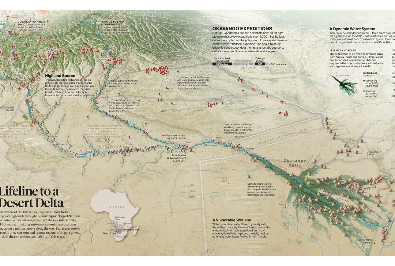
Map designed and created by National Geographic Magazine
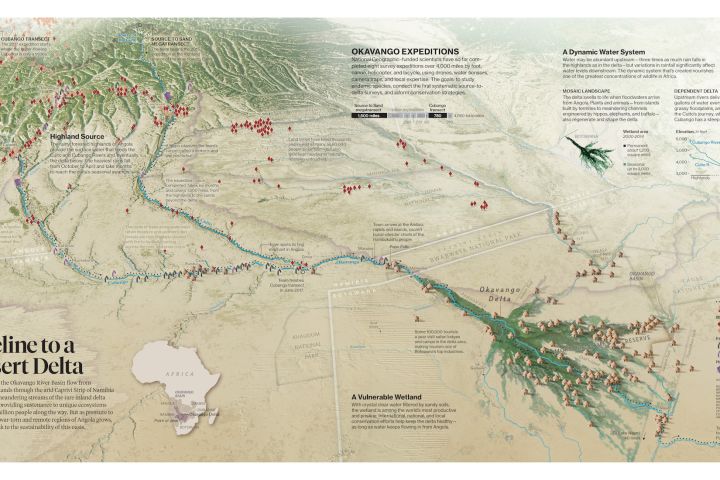
The "Lifeline to a Desert Delta" map offers students a study of the complexities of the watershed of the Okavango Delta in Africa. The Into The Okavango movie trailer will transport students to this unique region as they are introduced to the diverse team of scientists and National Geographic Explorers charged with surveying and protecting the river system. Use these ideas and Okavango Wilderness Project resources to help students discover ways to investigate and engage in watershed ecology, conservation research, and global geographic concepts.
Stressed Out
The dictionary defines “stressed out” as suffering from high levels of physical or psychological stress. Start by asking the class: Can water resources be stressed out? Then introduce them to freshwater conservationist Sandra Postel, and have them learn about water stress. Have students write a definition of water stress in their journals and give one local example and one global example. Then have students use the "Lifeline to a Desert Delta" map to look for locations where there may be water stress. Find out if the Okavango watershed is classified as stressed by exploring the Freshwater Availability map. You can go deeper with this topic by using Okavango Wilderness Project resources to research specific water stressors and corresponding conservation efforts.
Can We Work Together?
The Okavango watershed crosses the borders of three African countries. Have students read this encyclopedic entry about borders to learn about border disputes that involve natural resources. Ensure they are clear on what constitutes a natural resource, then display the "Lifeline to a Desert Delta" map. Ask students to draw red circles around any features or text on the map that represent important natural resources for the country of Botswana. Repeat this with green circles for the natural resources in Namibia. Then use blue circles to identify the natural resources in Angola. Ask students: How many of the different colored circles are drawn around water features on the map? Lead a class discussion that starts with this question: Could the ownership of those natural resources be a source of conflict?
Ask students to write a journal response about ways that these three nations could work together to share resources and support the health of the Okavango watershed. Ask: Are these ideas already a reality? As a class, read about the interdisciplinary team of scientists and Explorers working to protect the Okavango watershed. Then, as a class, have students share their thoughts about the team’s efforts. Consider using the students’ journal entries as a launching point to learn more about international conflict and cooperation.
Crossing Boundaries
Boundaries are dividing lines that mark the limits of an area. Have students explore the difference between a physical boundary and a political boundary by reading this encyclopedic entry. Ask: Why are the borders of countries located in certain places? Then have students identify the various boundaries depicted in the "Lifeline to a Desert Delta" map. Have students work independently to make a list of three physical boundaries and three political boundaries in the Okavango watershed. Remind them to cite specific information and details from the map to support their boundary choices. Then ask students to work together in pairs or in groups, comparing their lists and presenting their combined findings to the class.
Watershed Diversity
Watersheds are areas drained by a river and its tributaries. Guide students in an exploration of a global understanding of watersheds by having them collaborate on the Mapping the World’s Watersheds activity. Modify part three of this activity to focus on the Okavango Delta watershed. Have students use the "Lifeline to a Desert Delta" map to locate and trace the Okavango Delta watershed. Have students download the map for the high-resolution version. Then, in part four of the Mapping the World's Watersheds activity, have them compare and contrast the shapes of the Okavango Delta and Chesapeake Bay watersheds by exploring the Satellite Image of the Chesapeake Bay Watershed. To conclude, have students use the map to track water flow in and out of the Okavango Delta system.
Freshwater Sources
Use this encyclopedic entry on deltas to compile a list of the various types of deltas—and the qualifications for each—for students to review. Then have students use the "Lifeline to a Desert Delta" map and their own research to identify and describe the classification that best fits the Okavango Delta. Students should determine that it is an inland delta.
Then, have students use the map to learn more about the dynamic freshwater system in this delta and watch the video "Sand to Source" for a richer understanding of an Okavango Delta expedition. As a class, briefly discuss the video and ask students to write a journal response to the questions: What do you think is the number one reason that conservation of freshwater in the Okavango Delta is important? Why?
Next, direct students to study the map and read about the Okavango Source Lakes Survey. Instruct students to reread their journal entry then either elaborate on or revise their view based on the new information.
Media Credits
The audio, illustrations, photos, and videos are credited beneath the media asset, except for promotional images, which generally link to another page that contains the media credit. The Rights Holder for media is the person or group credited.
Director
Author
Production Managers
Program Specialists
Producer
Intern
other
Last Updated
April 15, 2024
For information on user permissions, please read our Terms of Service. If you have questions about how to cite anything on our website in your project or classroom presentation, please contact your teacher. They will best know the preferred format. When you reach out to them, you will need the page title, URL, and the date you accessed the resource.
Media
If a media asset is downloadable, a download button appears in the corner of the media viewer. If no button appears, you cannot download or save the media.
Text
Text on this page is printable and can be used according to our Terms of Service.
Interactives
Any interactives on this page can only be played while you are visiting our website. You cannot download interactives.