Earthquakes in history
1. SAN FRANCISCO
"Not in history has a modern imperial city been so completely destroyed. San Francisco is gone. Nothing remains of it but memories and a fringe of dwelling-houses on its outskirts,"
Jack London’s eyewitness account.
Stats
-
 Date: April 18, 1906, 5:12 a.m
-
 Magnitude: 7.9 (estimated)
-
 Dead: Approximately 700 (some archivists estimate closer to 3,000)
-
 Damage: 28,000 buildings destroyed
- Among the strongest earthquakes ever recorded on the North American continent, this earthquake was felt from southern Oregon to Los Angeles and east to central Nevada. Nearly 480 kilometers (300 miles) of ground—almost half the length of California—fractured along the San Andreas Fault.
- Nearly a minute of severe shaking crippled the city, toppling buildings into the streets. The quake sparked several extensive fires, which burned out of control for three days. Nearly 600 city blocks were consumed in the fires.
- More than 200,000 people, almost half of the city's population, were suddenly homeless. Thousands camped in Golden Gate Park watching flames sweep the city. The mayor issued a proclamation authorizing police to kill looters. Refugees packed trains heading anywhere away from the San Francisco Bay area.
- If a similar quake struck Northern California today, experts say the results could be catastrophic. Thousands of people could be killed and economic losses would reach hundreds of billions of dollars.
"Everybody in San Francisco is prepared to leave the city, for the belief is firm that San Francisco will be totally destroyed," wrote a local newspaper on April 19. "Downtown everything is ruin. Not a business house stands... On every side there was death and suffering yesterday. Hundreds were injured, either burned, crushed or struck by falling pieces from the buildings."
Seismologists believe a period of strong quake activity in the Bay area may be currently under way. In 2015, the USGS reported that there is a 72% chance that one or more quakes of about magnitude 6.7 or larger will occur in the San Francisco Bay area before the year 2030.
-
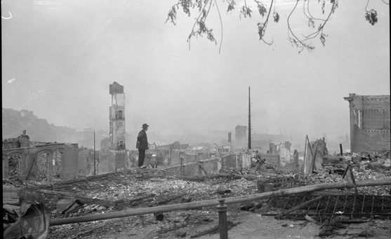
Standing on the ruins, April 1906, Chinatown, San Francisco. Genthe photograph collection, Library of Congress, Prints and Photographs Division.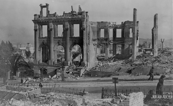
Ruins after San Francisco earthquake, 1906. Photograph by Library of Congress -
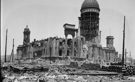
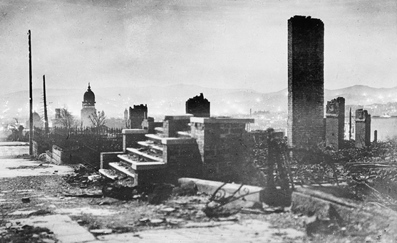
Ruins of City Hall after San Francisco earthquake, 1906. Photograph by Library of Congress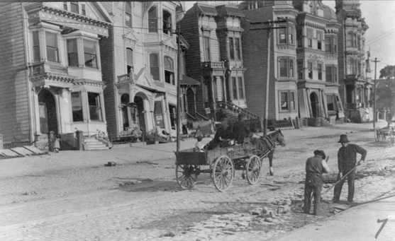
Two men cleaning street, horse-drawn wagon and damaged buildings in the background, after the 1906 San Francisco earthquake. Photograph by Library of Congress -
San Francisco earthquake and fire of 1906. Photograph by Library of Congress
2. TANGSHAN, CHINA
Stats
-
Date: July 28, 1976, 4 a.m.
-
Magnitude: 7.8
-
Dead: At least 240,000
-
 Injured: At least 700,000
-
Damage: 85 percent of buildings destroyed
With no structures built for earthquake resistance, Tangshan was a sitting duck. This city of one million, about 110 kilometers (68 miles) east of Beijing (Peking), was nearly decimated when a moment magnitude 7.8 quake shook it awake in 1976. A major aftershock followed 15 hours later.
When the dust settled, a staggering 240,000 people had been killed, and at least 700,000 more were injured—the largest global earthquake death toll in the past 400 years.
The city was nearly razed. Systems that failed were:- electricity
- water supply
- sewer system
- telephone and radio communications
Tangshan's coal mines were destroyed. Collapsed highways and railroads isolated the city and kept rescuers and aid away.
Although the Tan-Lu Fault runs close to the city, experts had estimated that Tangshan had a low probability of being hit hard by an earthquake. As a result the city was ill-prepared for the unexpected quake.
Nearly 95 percent of the city's homes and 78 percent of commercial buildings were destroyed. Most victims were killed when their unreinforced masonry homes collapsed while they were asleep. In one College Mining Institute dormitory alone, more than 2,000 students died.
-
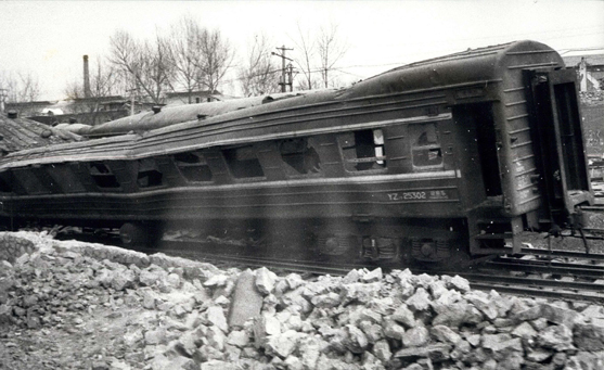
UN image showing damage to train carriage on the outskirts of Tangshan. Photograph by ZUMA Press, Inc. / Alamy Stock Photo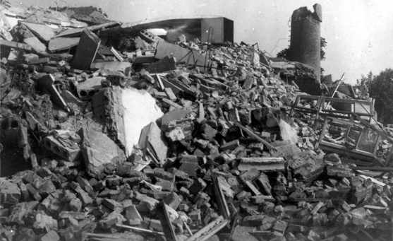
Ruins of the Tangshan People's Bank, a four-story concrete and brick building. Photograph by World History Archive / Newscom -
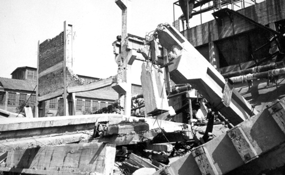
Earthquake damage at Tangshan rolling stock plant, July 28, 1976. Photograph by World History Archive / Newscom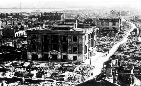
Devastation in Tangshan after the 1976 earthquake. Photograph by World History Archive / Newscom -
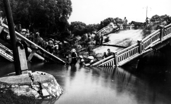
Destroyed Chengli Bridge, Tangshan, China. Photograph by World History Archive / Newscom
3. LOMA PRIETA, CALIFORNIA
Stats
-
Date: October 17, 1989, 5:04 p.m.
-
Magnitude: 6.9
-
Dead: 63
-
Injured: Nearly 3,800
-
Damage: Over 28,000 homes and businesses
More than 62,000 baseball fans were crowded into San Francisco's Candlestick Park, waiting for game three of baseball's 1989 World Series to begin when the ground began to shake.
A segment of the infamous San Andreas Fault had ruptured under Loma Prieta Peak in the Santa Cruz Mountains. The explosive release of energy lifted the mountains themselves and sent shock waves shooting through the Earth.
- The city of Santa Cruz, 16 kilometers (10 miles) from the epicenter, was ripped apart first.
- The town of Watsonville, a center for frozen-vegetable processing, was devastated.
- Then the shock waves flew up the peninsula toward heavily populated San Francisco.
There the quake peeled a section of the San Francisco Bay Bridge open and collapsed a section of the upper deck of Oakland's Interstate 880. More than 40 slabs of concrete, each weighing 600 tons, slammed onto cars below.
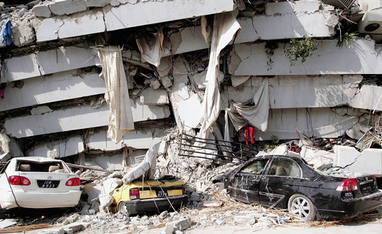
The worst damage was in San Francisco's Marina district. Mud and sand, originally pumped in to fill shallow waters, had not been properly compacted. The quake's seismic waves turned the unstable soil into slush, in a process called liquefaction. Surface waves amplified ground shaking, as homes and businesses toppled into the slush, which acted like quicksand.
When the seconds-long earthquake was over, 63 people were dead or dying and nearly 3,800 people were injured. More than 28,000 structures were damaged—but not Candlestick Park. The World Series fans were rattled but unharmed.
Although California escaped with relatively few fatalities, experts stress that the Loma Prieta quake—despite its magnitude—was just a dress rehearsal. They conclude a bigger earthquake is on its way, probably sooner rather than later.
-
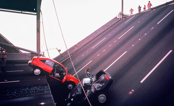
Two cars caught when the San Francisco-Oakland Bay Bridge collapsed after the 1989 Loma Prieta earthquake. Photograph by Chuck Nacke / Alamy Stock Photo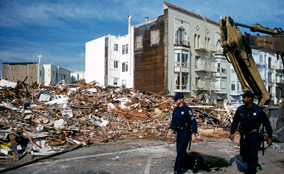
Damage in the Marina District of San Francisco from the Loma Prieta earthquake of October 17, 1989. Photograph by Robert Fried / Alamy Stock Photo -
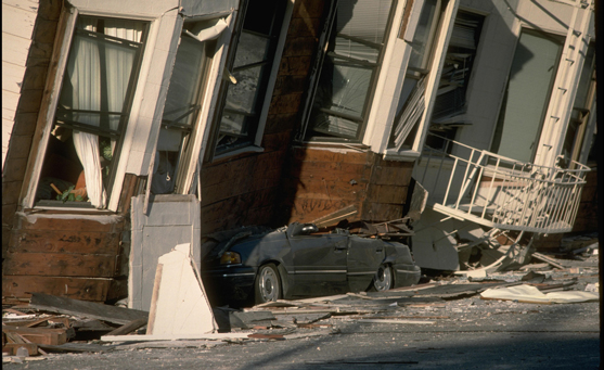
A house collapsed on to a parked car during the 1989 Loma Prieta earthquake, San Francisco, California. Photograph by Gado Images / Alamy Stock Photo
Rescue workers and police enter the scene of destruction where the Interstate 880-Interstate 80 interchange collapsed in Oakland during the Loma Prieta earthquake. Photograph by Tom Van Dyke / MCT / Newscom -

The October 1989 Loma Prieta earthquake damaged a building on Cervantes and Alhmabra streets in the Marina district of San Francisco, California. Photograph by Rick E. Martin / TNS / Newscom
4. Kōbe, Japan
Stats
-
Date: January 17, 1995, 5:46 a.m.
-
Magnitude: 6.9
-
Dead: More than 5,500
This major Japanese port town was struck by an earthquake that left more than 5,500 people dead and nearly 300,000 homeless.
Traditional Japanese building methods—post-and-beam constructions with heavy tile roofs—left many homes vulnerable, and much of Kōbe was built on the worst possible soil for quakes: very soft, uncompacted dirt and fill. When stirred by the quake's seismic waves, this soil turned into quicksand-like soup. Kōbe's port suffered massive damage.
Kōbe's port, built on artificial islands made of fill, suffered massive damage.
Buildings toppled sideways, and huge cranes fell into the harbor. Shipping worldwide was hampered for months.
The quake also destroyed or severely damaged most of the city's lifelines—highways, railways, and bridges—and debris choked its streets.
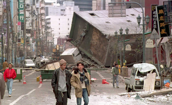
Firefighters could not reach most of the approximately 300 fires that broke out after the quake, and many sections of the city burned to the ground. Calm winds kept the fires from spreading and consuming all of Kōbe.
-
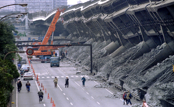
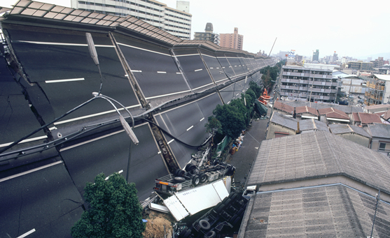
A giant crane pulls crushed cars out of the debris January 18, 1995, after the Hanshin Expressway in Kōbe was devastated during the worst earthquake in Japan in nearly 50 years. Photograph by Stringer / Reuters / Newscom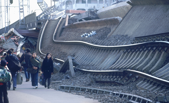
Collapsed railway in Hyogo, Japan after Kōbe earthquake, 1995. Photograph by Pacific Press Service / Alamy Stock Photo -
A collapsed building blocks the main street of central Kōbe, 18 January, 1995. Photograph by Toru Yamakaka / Getty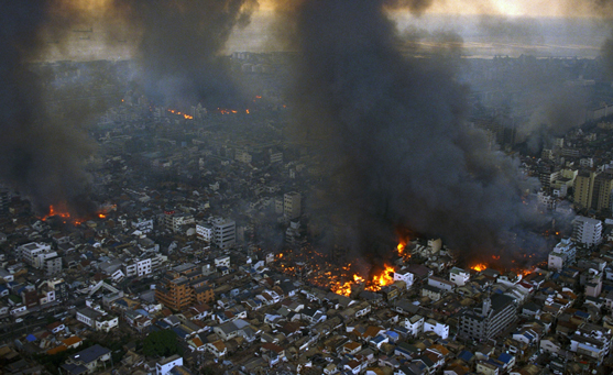
Kōbe city is ablaze after the strong earthquake on January 17, 1995. Photograph by The Asahi Shimbun / Getty -
Collapsed highway in Hyogo, Japan after Kōbe earthquake, 1995. Photograph by Pacific Press Service / Alamy Stock Photo
5. BAM, IRAN
Stats
-
Date: December 26, 2003, 5:28 a.m.
-
Magnitude: 6.5
-
Dead: More than 26,000
-
Injured: 30,000
-
Damage: 80 percent of buildings damaged or destroyed
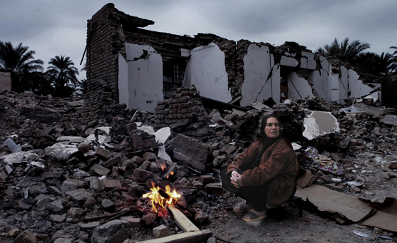
In the days of the famed Silk Road, Bam, Iran, was renowned for its textiles and fire temple. More recently, the ancient city grew prize date fruits and attracted tourists with Arg e-Bam, the largest earthen citadel in the world.
A few seconds in 2003 changed all that. Triggered just below the city, the earthquake leveled much of Bam and killed more than 26,000 people.
Many of the structures in Bam were poorly designed to withstand an earthquake, as they were mud-brick constructions that collapsed quickly on sleeping inhabitants. In all, approximately 45,000 homes were destroyed, as well as a large part of the 2,000-year-old citadel.
The quake also severely damaged Bam's ancient underground irrigation systems. Called qanats, these man-made channels carried water to residents and the city's lush date-palm groves. Most of the qanats were damaged in the quake, and many were destroyed, putting the date crops—and the city's future—in jeopardy.
-
Mohammed-Ali Dashti returns from a pilgrimage to Kerbala, Iraq, December 30 to find all his family killed in the earthquake. He is grieving for his pregnant wife and three children. Photograph by 2003 Harald Henden / Black Star / Newscom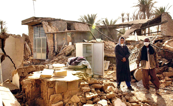
Tahereh Kafashi and her husband Hussain Rajabi stand in the ruins of their former home in the city of Bam, Iran, December 29, 2003. The couple borrowed money to build the house, which was completed five hours before the earthquake. The Rajabi family lost 150 members in the quake. Photograph by Arash A. Nejad / SCANPIX iPhoto Inc. / Newscom -
Two Iranian workers rebuild a home destroyed by the previous year's earthquake in Bam on September 12, 2004. Photograph by Morteza Nikoubazi / Reuters / Newscom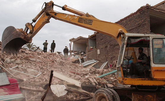
Rescue workers recover an earthquke victim in Bam, Iran, December 28, 2003. Photograph by Ali Khaligh / UPI / Alamy Stock Photo
6. Kashmir, Pakistan
Stats
-
Date: October 8, 2005
-
Magnitude: 7.6
-
Dead: Approximately 79,000 in Kashmir, more in India and Afghanistan
-
Injured: Approximately 69,000 in Kashmir, more in India and Afghanistan
This earthquake was the result of a collision between the Indian and Eurasian plates. Poorly constructed buildings led to great loss of life and damage to property, with at least 32,335 buildings collapsing in the Kashmir region.
Sewage pipes broke, contaminating water supplies, and spreading disease. There were numerous aftershocks. Large fractures appeared in the ground, and landslides damaged roads, hampering the relief effort.
The army and emergency services joined the rescue effort, with aid workers from abroad helping survivors and treating the injured. Charities gave out tents, but many people died of cold during the harsh winter that followed.
Huge amounts of rebuilding were needed, including schools and hospitals. Building regulations had to be improved, to help the region become more resilient to any future quakes.
-
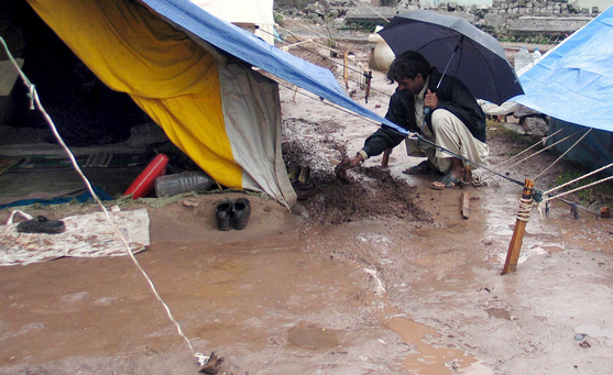
A survivor puts mud around his temporary shelter to block rainwater in quake-hit Muzaffarabad, capital of Pakistan-administered Kashmir, on January 1, 2006. Photograph by Aftab Mir / EPA / Shutterstock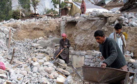
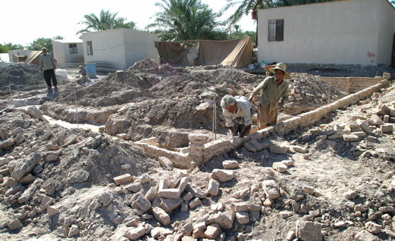
Earthquake survivors rebuild their collapsed houses in the quake-hit village of Rangata near Muzaffarabad, Pakistan-administered Kashmir, on 23 December, 2005. Photograph by Aftab Mir / EPA / Shutterstock -
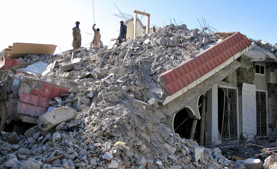
Cars are flattened underneath a collapsed apartment building after the 2005 earthquake in Islamabad, Pakistan. Photograph by Warrick Page / Getty Images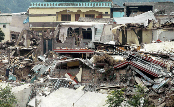
A Pakistani quake survivor walks past collapsed houses in Batagram on 25 October 25, 2005. Tens of thousands of people remain without adequate shelter and food more than two weeks after the October 8 disaster. Photograph by FAROOQ NAEEM/AFP via Getty Images -
Pakistani Kashmiri labourers work on a collapsed house in the earthquake-devastated city of Muzaffarabad, the capital city of Pakistan-administered Kashmir, on April 8, 2006. Six months after the disaster, reconstruction is yet to start in most of the devastated area. Photograph by SAJJAD QAYYUM/AFP via Getty Images
7. TIRANE (TIRANA), ALBANIA
Stats
-
Date: November 26, 2019
-
Magnitude: 6.4
-
Dead: 51
-
Injured: Approximately 2,000
This 6.4 magnitude quake was the deadliest to hit the country since 1979. Most of the fatalities occurred in the towns of Durrёs and Thumanё, after the quake struck 34 kilometers (21 miles) north-west of the capital, Tirana.
The quake occurred as people slept, so most deaths were due to buildings collapses. The government blamed poor construction of buildings for the destruction and death toll. About 4,000 people became homeless. Tirana International Airport was closed because its buildings were damaged.
In the days that followed there were hundreds of aftershocks, some with a moment magnitude more than 5.0. Shocks were felt as far away as southern Italy and northern Greece.
-
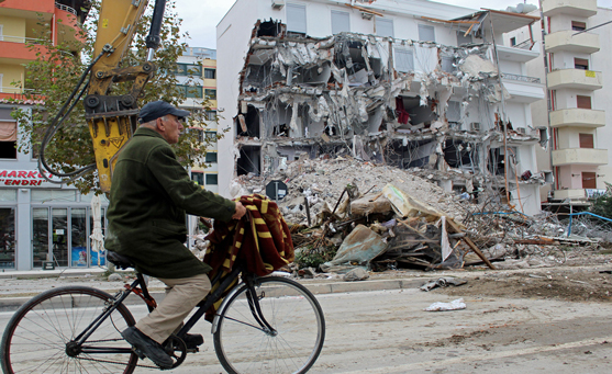
A cyclist passes a damaged building in Durres, Albania, December 2, 2019. Photograph by Malton Dibra / EPA-EFE / Shutterstock
The Albanian army uses a remote-controlled explosion to demolish a quake-damaged six-storey building in the western port city of Durres, Albania, Photograph by Hektor Pustina / AP / Shutterstock -
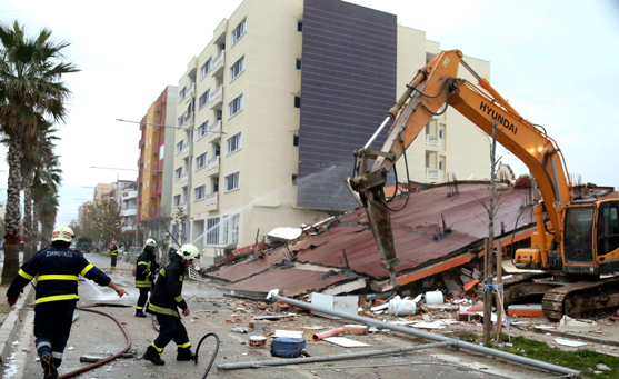
Firefighters clean the road from debris after a remote-controlled explosion to demolish a quake-damaged six-storey building in the western port city of Durres, Albania. Photograph by Hektor Pustina / AP / Shutterstock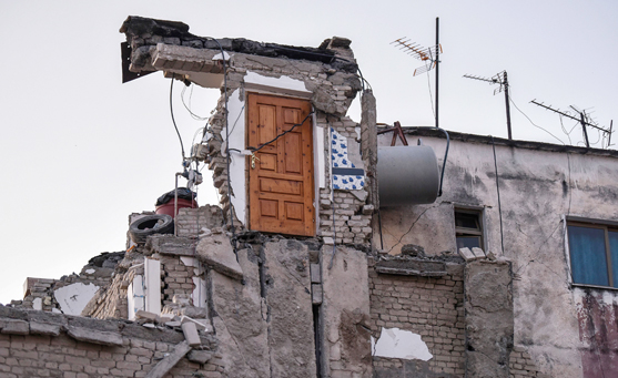
Albanian rescuers dig through rubble in Thumane, northwest of capital Tirana, on November 26, 2019 as desperate survivors trapped in toppled buildings cry out for help. Photograph by Armend Nimani / Getty Images -
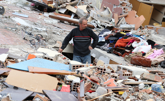
A man stands in the rubble of a collapsed building after a 6.3-magnitude earthquake hit Albania's Durres city on November 28, 2019. Photograph by Anadolu Agency / Getty Images