Scientists estimated that in 1990, 31 million homes were located in “wildland-urban interface” (WUI) areas throughout the Unites States—areas with houses that are in or near wildland vegetation, which imparts a greater risk of wildfire due to the proximity to flammable vegetation. Twenty years later, in 2010, that number increased by 41 percent to 43 million homes.
The increase is fueled by a number of factors, including urban sprawl and the hunt for a lower cost of living. The spread is occurring not only in wildfire-prone places like California and other western states, but also in New England.
Experts say one thing is certain—people who build homes close to forests and other types of natural vegetation raise the risk of wildfires. Wildfires are uncontrolled fires, caused by humans or nature, in landscape covered with vegetation. With continued growth in the interface, the onus to mitigate wildfire risks has shifted from firefighters to homeowners and city planners, as well as local, state, and federal governments.
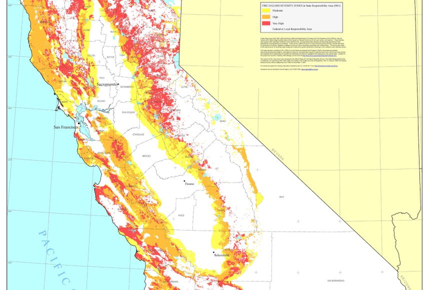
For example, the California Department of Forestry and Fire Protection (Cal Fire), Office of the State Fire Marshall has developed a map to identify fire hazard severity zones throughout the state. The map shows an estimate of where a wildfire would burn and takes into account vegetation, fire history, and weather, among other factors. The map categorizes hazards as very high, high, and moderate. Wind is another factor that can influence the presence and severity of a wildfire. Extreme winds can spread fire beyond the hazardous areas, which happened during California wildfires in 2017 and 2018, so those who live outside high-risk zones should also take caution. Wind also removes moisture from already dry vegetation and pushes the fire to other areas faster. The next iteration of the map plans to take into account how wind can affect wildfires.
California cities located in very high fire hazard severity zones are mandated by state law to notify the public of the designation and adopt local ordinances.
Ordinances include:
- Meeting state brush clearance and defensible space requirements, which involves clearing out dead leaves and brush; mowing weeds and grasses; and establishing gaps between trees and shrubs. This is typically referred to as creating a fuel break.
- Building new structures that comply with California building code requirements, such as using fire-retardant roofing materials and ignition resistant construction, among other materials.
Homeowners can also create a firebreak—a break in vegetation that helps prevent the spread of wildfires and control prescribed burns. Examples of fire breaks include a gravel road or a river. “Green” fire breaks use grasses with high moisture content to break the continuity of the fuel, the flammable material surrounding a fire. Grazing livestock can also remove fuel sources.
Firebreaks define the perimeter of a prescribed burn. Prescribed or controlled burns are a common tool for managing the buildup and removal of hazardous fuel sources but are typically planned and executed by firefighters.
In the event of a wildfire, people living in communities that are at risk of wildfires should pay close attention to the community’s warning system as well as to the Emergency Alert System and the National Oceanic and Atmospheric Administration weather radio for emergency alerts. People living in these areas should also know the community’s evacuation plan and several ways to leave the area prior to a wildfire warning. This can include driving the evacuation routes before a fire occurs and finding shelter locations. Plans should also be developed for pets and livestock.
Every household in at-risk communities should have emergency supplies, including a respirator mask that filters out smoke and air pollutants like carbon dioxide, carbon monoxide, and particles that contain chemicals from materials that have burned. Smoke from wildfires irritates the eyes, nose, and respiratory system. Signs of smoke inhalation include shortness of breath, headaches, and dizziness, and it can exacerbate asthma and heart problems. Over time, long-term exposure to smoke from fires may lead to chronic and deadly health conditions like heart and lung disease.
If trapped during a wildfire, a respirator mask should be used to keep harmful particles out of the air being breathed. If smoky conditions exist but there is no need to evacuate, stay inside or retreat to a community building where smoke levels remain low. Homeowners should designate a room in the house that can be closed off from outside air.
In addition, homeowners should keep important documents in a safe, fireproof place so that they can be accessed in the event of a fire. Review the insurance policy to make sure it offers sufficient coverage to replace damaged portions of the property—or the property in its entirety—in the event of a wildfire.
After a wildfire, listen to local authorities to learn when it is safe to return home and whether the water is safe to consume, as wildfires can transport sediment and debris into reservoirs and water treatment plants. Avoid hot, charred, or smoldering debris and live embers as there may be hotspots that can cause burns or spark another fire.
Wildfires can drastically alter the surrounding landscape and ground conditions, which increases the risk of flash flooding and mudflows. This risk remains high until the natural vegetation is restored, which scientists estimate can take upwards of five years.