Hawai'i, that honeymoon destination known for stunning sunsets, has a dark secret—it’s a geologically violent place. That’s because the Hawaiian Islands were born from volcanic activity. In fact, that volcanism can still be observed today in Hawai'i.
The six largest Hawaiian Islands—the Big Island, Maui, Lanai, Molokai, Oahu, and Kauai—form a chain of islands running to the northwest. The islands appear in this pattern for a specific reason: They were formed one after the other as a tectonic plate, the Pacific Plate, slid over a plume of magma—molten rock—puncturing Earth’s crust. These magma plumes aren’t small—they can extend hundreds of kilometers below Earth’s surface.
This upwelling of molten rock, known as a “hot spot,” creates volcanoes that spew out lava (magma that reaches Earth’s surface). The lava then cools and hardens to create new land. The Hawaiian Islands were literally created from lots of volcanoes—they’re a trail of volcanic eruptions.
Hot-spot volcanism can occur in the middle of tectonic plates. That’s unlike traditional volcanism, which takes place at plate boundaries. One explanation that scientists have proposed for hot-spot volcanism is that it occurs near unusually hot parts of Earth’s mantle, the layer of the planet below the crust.
In the case of the Hawaiian Islands, the Pacific Plate is continually moving to the northwest over the Hawaiian hot spot. This movement caused the Hawaiian chain of islands to form. The Pacific Plate is just one of the Earth’s roughly 20 tectonic plates, which are constantly in motion and are responsible for events like earthquakes.
There are many landforms around the Hawaiian Islands that formed from the same volcanic hot spot. Scientists believe this hot spot has been expelling lava for roughly 70 million years.
Many of these landforms created by volcanoes are still submerged. Also submerged are the peaks of the Emperor Seamount to the northwest of Hawai'i, which is part of the same chain of volcanic formations. A seamount is a submarine mountain. The Emperor Seamount extends for more than 6,000 kilometers (3,728 miles) from Hawai'i up to the Aleutian Trench in Alaska. In total, more than 750,000 cubic kilometers (180,000 cubic miles) of lava erupted to form all of the landforms in the Hawaiian–Emperor chain. That’s enough to cover the entire state of California in a layer of lava more than one kilometer (0.62 mile) thick.
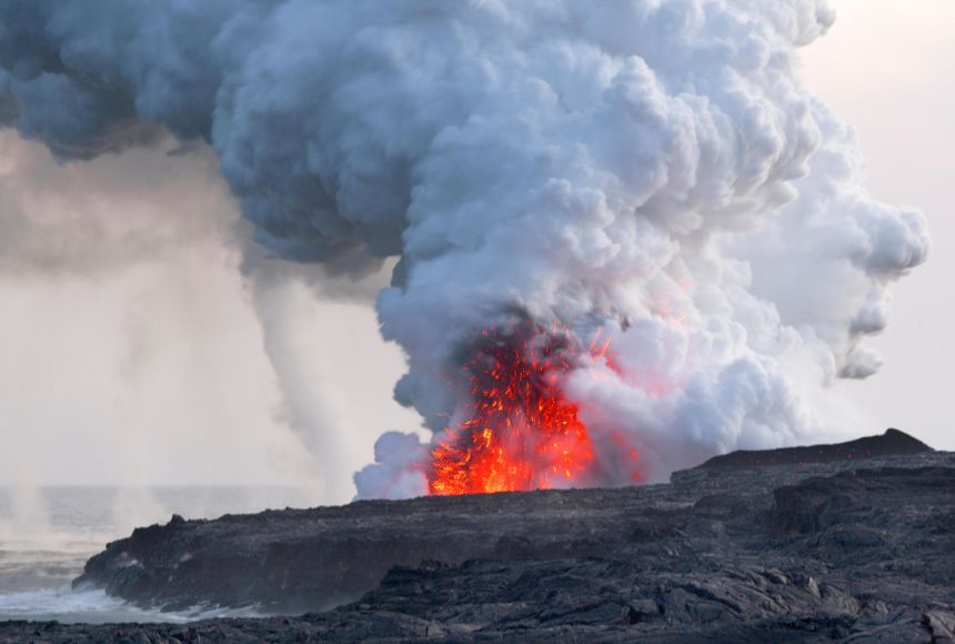
Volcanic activity is still occurring on the southern shore of the Big Island, the youngest of the Hawaiian Islands. In 2018, the Kilauea volcano erupted spectacularly and inundated over 30 square kilometers (30.5 square miles) of the Big Island with lava. The layer of lava was up to 24 meters (79 feet) thick in places—taller than a six-story building. Thousands of earthquakes accompanied the eruptions, and nearby residents and staff at the United States Geological Survey’s Hawaiian Volcano Observatory near Kilauea were forced to evacuate.
Kilauea isn’t the only volcano on the Big Island. There are also Kohala, Mauna Kea, Hualalai, and Mauna Loa. Of these four volcanoes, only Hualalai and Mauna Loa are active. Mauna Kea, a dormant volcano on the Big Island, is in fact the tallest mountain in the world measured from its base to its top. It’s over 10,000 meters (32,800 feet) tall, significantly taller than Mt. Everest. But nearly 6,000 meters (19,700 feet) of its height is below the sea, so we only see about 4,000 meters (13,000 feet) of it.
The oldest of the major Hawaiian Islands, Kauai, doesn’t have any active volcanoes because it’s no longer over the Hawaiian hot spot. Instead, the dominant ecological process occurring there is erosion, which has sculpted Kauai’s landscape into beautiful cliffs.
As the Pacific Plate continues to move at a rate of roughly seven centimeters (2.75 inches) per year—about the rate at which fingernails grow—new volcanic material is building up over the Hawaiian hot spot. This material will eventually form another Hawaiian island. Located about 35 kilometers (22 miles) off the southern coast of the Big Island, this future island already has a name: Loihi. But don’t book a trip there just yet—Loihi is not visible as an island right now. It’s grown by thousands of meters already, but it is still roughly 1,000 meters (3,280 feet) below the surface of the Pacific Ocean. As lava continues to be deposited on Loihi, scientists predict that it will rise above sea level sometime between 10,000 and 100,000 years from now.
Scientists think that seamounts like Loihi may resemble worlds in the outer solar system like Saturn’s moon Enceladus. By studying the conditions in the deep sea around Loihi, researchers can better understand what other worlds in the solar system may look like.